AccuWeather


- Flood Warning
...The Flood Warning continues for the following rivers in Texas... Long King Creek near Livingston affecting San Jacinto and Polk Counties. For the Long King Creek...including Livingston...Moderate flooding is forecast. * WHAT...Moderate flooding is occurring and moderate flooding is forecast. * WHERE...Long King Creek near Livingston. * WHEN...Until late tomorrow morning. * IMPACTS...At 25.0 feet, At levels above 25 feet moderate lowland flooding begins as low lying areas along the creek become innundated. * ADDITIONAL DETAILS... - At 6:01 AM CDT Monday the stage was 25.1 feet. - Bankfull stage is 14.0 feet. - Recent Activity...The maximum river stage in the 24 hours ending at 6:01 AM CDT Monday was 25.1 feet. - Forecast...The river is expected to rise to a crest of 25.3 feet this afternoon. It will then fall below flood stage late this evening. - Flood stage is 19.0 feet. - Flood History...This crest compares to a previous crest of 25.3 feet on 03/11/2016. - http://www.weather.gov/safety/floodMore
- Flash Flood Warning
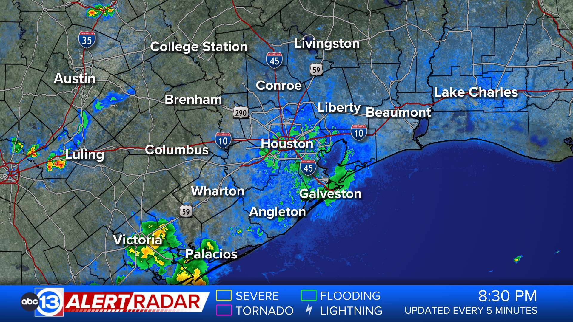
FFWHGX The National Weather Service in League City has issued a * Flash Flood Warning for... Central Galveston County in southeastern Texas... * Until 915 AM CDT. * At 609 AM CDT, Doppler radar and automated rain gauges indicated thunderstorms producing heavy rain across the warned area. Between 2 and 4 inches of rain have fallen. Additional rainfall amounts of 1 to 3 inches are possible in the warned area. Flash flooding is ongoing or expected to begin shortly. HAZARD...Flash flooding caused by thunderstorms. SOURCE...Radar and automated gauges. IMPACT...Flash flooding of small creeks and streams, urban areas, highways, streets and underpasses as well as other poor drainage and low-lying areas. * Some locations that will experience flash flooding include... Texas City, La Marque, Hitchcock and Bayou Vista. This includes the following Low Water Crossings... Laurel Street at Lower Highland Bayou Tributary and State Highway 6 at Interstate 45 South.More
- Flood Advisory
* WHAT...Urban and small stream flooding caused by excessive rainfall is expected. * WHERE...A portion of southeast Texas, including the following county, Galveston. * WHEN...Until 730 AM CDT. * IMPACTS...Minor flooding in low-lying and poor drainage areas. * ADDITIONAL DETAILS... - At 538 AM CDT, Doppler radar indicated heavy rain due to thunderstorms. This will cause urban and small stream flooding. Between 1 and 3 inches of rain have fallen. - Additional rainfall amounts of 1 to 2 inches are expected over the area. This additional rain will result in minor flooding. - Some locations that will experience flooding include... Galveston Causeway, Galveston Island West End, Texas City, La Marque, Hitchcock, Galveston Pier 21, Bayou Vista, Tiki Island, Pelican Island, Offatts Bayou, Galveston Island East End, The Strand, Moody Gardens, Schlitterbahn, Scholes Field, Galveston Pleasure Pier, Port Bolivar, Crystal Beach and Bolivar Peninsula. - http://www.weather.gov/safety/floodMore
- Flash Flood Warning
FFWHGX The National Weather Service in League City has issued a * Flash Flood Warning for... Northwestern Chambers County in southeastern Texas... * Until 800 AM CDT. * At 450 AM CDT, Doppler radar and automated rain gauges indicated thunderstorms producing heavy rain across the warned area. Between 4 and 7 inches of rain have fallen. Additional rainfall amounts of 1 to 2 inches are possible in the warned area. Flash flooding is ongoing or expected to begin shortly. HAZARD...Life threatening flash flooding. Thunderstorms producing flash flooding. SOURCE...Radar and automated gauges. IMPACT...Life threatening flash flooding of creeks and streams, urban areas, highways, streets and underpasses. * Some locations that will experience flash flooding include... Northeastern Baytown, Mont Belvieu, Old River-Winfree and Cove. This includes the following Low Water Crossings... Winfree Street at Smith Gully.More
- Flash Flood Warning
FFWHGX The National Weather Service in League City has issued a * Flash Flood Warning for... Northwestern Chambers County in southeastern Texas... Harris County in southeastern Texas... South Central Liberty County in southeastern Texas... * Until 715 AM CDT. * At 403 AM CDT, Doppler radar and automated rain gauges indicated thunderstorms producing heavy rain across the warned area. Between 2 and 4 inches of rain have fallen. Additional rainfall amounts of 2 to 3 inches are possible in the warned area. Flash flooding is ongoing or expected to begin shortly. HAZARD...Flash flooding caused by thunderstorms. SOURCE...Radar and automated gauges. IMPACT...Flash flooding of small creeks and streams, urban areas, highways, streets and underpasses as well as other poor drainage and low-lying areas. * Some locations that will experience flash flooding include... Pasadena, Baytown, Deer Park, South Houston, Galena Park, Beach City, Highlands, Barrett, Channelview, Cloverleaf, Mont Belvieu, Shoreacres, Old River-Winfree, Cove, Morgan's Point, San Jacinto State Park, Sheldon, Houston Ship Channel, Northshore and Wallisville.More
- Flood Watch
* WHAT...Flooding caused by excessive rainfall continues to be possible. * WHERE...A portion of southeast Texas, including the following areas, Grimes, Montgomery, Northern Liberty, Polk, San Jacinto, Trinity and Walker. * WHEN...Until 10 AM CDT this morning. * IMPACTS...Excessive runoff may result in flooding of rivers, creeks, streams, and other low-lying and flood-prone locations. Creeks and streams may rise out of their banks. Flooding may occur in poor drainage and urban areas. Low-water crossings may be flooded. Extensive street flooding and flooding of creeks and rivers are possible. * ADDITIONAL DETAILS... - Training heavy rain continues to sag southward across the region - http://www.weather.gov/safety/floodMore
- Beach Hazards Statement
* WHAT...A high risk of rip currents, elevated surf and water levels. * WHERE...Gulf-facing beaches, including the Matagorda Peninsula, Brazoria County beaches, Galveston Island and the Bolivar Peninsula. * WHEN...Through this evening. * IMPACTS...Dangerous swimming conditions.More
- Flood Warning
...The National Weather Service in Houston/Galveston TX has issued a Flood Warning for the following rivers in Texas... Trinity River near Moss Bluff affecting Liberty and Chambers Counties. Long King Creek near Livingston affecting San Jacinto and Polk Counties. Bedias Creek near Madisonville affecting Walker and Madison Counties. Menard Creek near Rye affecting Liberty, Hardin and Polk Counties. For the Trinity River...including Crockett, Riverside, Romayor, Goodrich, Liberty, Moss Bluff...Moderate flooding is forecast. For the Long King Creek...including Livingston...Moderate flooding is forecast. * WHAT...Minor flooding is forecast. * WHERE...Trinity River near Moss Bluff. * WHEN...From early this morning until further notice. * IMPACTS...At 15.2 feet, Moderate lowland flooding begins in the vicinity of the gage. * ADDITIONAL DETAILS... - At 1:30 AM CDT Monday the stage was 12.1 feet. - Bankfull stage is 9.2 feet. - Forecast...The river will rise above flood stage early this morning to 12.9 feet this evening. It will then fall Wednesday morning. It will rise to 13.8 feet early Friday afternoon. It will then fall again but remain above flood stage. - Flood stage is 12.2 feet. - Flood History...This crest compares to a previous crest of 13.8 feet on 11/18/1998. - http://www.weather.gov/safety/floodMore
- Coastal Flood Advisory
* WHAT...For the High Rip Current Risk, dangerous rip currents. For the Coastal Flood Advisory, minor coastal flooding. * WHERE...Aransas Islands, Kleberg Islands, Nueces Islands and Calhoun Islands Counties. * WHEN...For the High Rip Current Risk, through Tuesday morning. For the Coastal Flood Advisory, until 7 PM CDT this evening. * IMPACTS...Flooding of lots, parks, and roads with only isolated road closures expected. Rip currents can sweep even the most experienced swimmers away from shore into deeper water. These rip currents can become life-threatening to anyone entering the surf.More
- Coastal Flood Advisory
* WHAT...Minor coastal flooding. * WHERE...Coastal Aransas, Coastal Kleberg, Coastal Nueces, Coastal San Patricio, Coastal Refugio and Coastal Calhoun Counties. * WHEN...Until 7 PM CDT Monday. * IMPACTS...Flooding of lots, parks, and roads with only isolated road closures expected.More
- Rip Current Statement
* WHAT...For the High Rip Current Risk, dangerous rip currents. For the Coastal Flood Advisory, minor coastal flooding. * WHERE...Aransas Islands, Kleberg Islands, Nueces Islands and Calhoun Islands Counties. * WHEN...For the High Rip Current Risk, through Tuesday morning. For the Coastal Flood Advisory, until 7 PM CDT this evening. * IMPACTS...Flooding of lots, parks, and roads with only isolated road closures expected. Rip currents can sweep even the most experienced swimmers away from shore into deeper water. These rip currents can become life-threatening to anyone entering the surf.More