AccuWeather


- Flood Warning
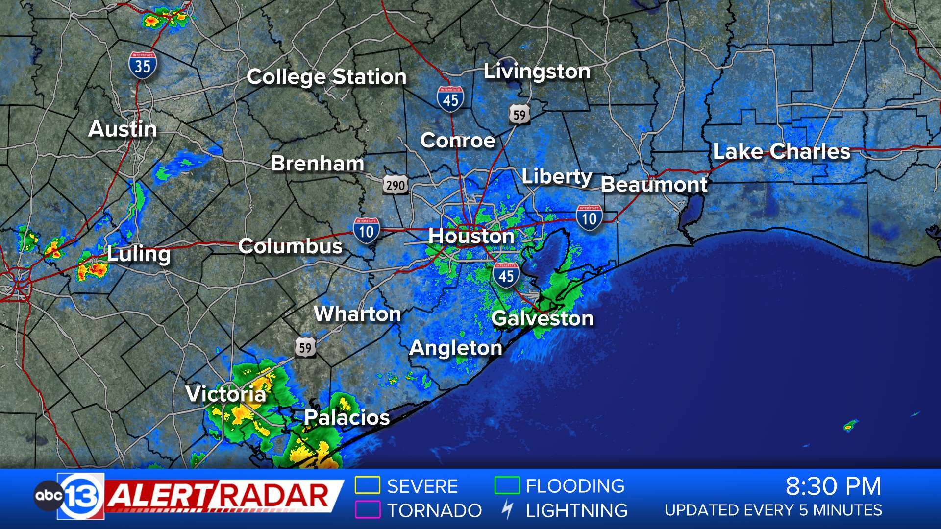
...The Flood Warning continues for the following rivers in Texas... West Fork San Jacinto near Humble affecting Montgomery and Harris Counties. For the West Fork San Jacinto River...including Humble...Minor flooding is forecast. * WHAT...Minor flooding is occurring and minor flooding is forecast. * WHERE...West Fork San Jacinto near Humble. * WHEN...Until Tuesday morning. * IMPACTS...At 49.3 feet, Minor lowland flooding begins in the vicinity of the gauge. North side turnaround at US 59 begins to flood. Low points on Thelma Road, Aqua Vista Drive, and Riverview Drive begin to flood. * ADDITIONAL DETAILS... - At 8:45 PM CDT Sunday the stage was 49.7 feet. - Bankfull stage is 45.3 feet. - Recent Activity...The maximum river stage in the 24 hours ending at 8:45 PM CDT Sunday was 49.7 feet. - Forecast...The river is expected to rise to a crest of 49.7 feet just after midnight tonight. It will then fall below flood stage tomorrow evening. - Flood stage is 49.3 feet. - Flood History...This crest compares to a previous crest of 49.7 feet on 11/13/2008. - http://www.weather.gov/safety/floodMore
- Flood Warning
...The Flood Warning continues for the following rivers in Texas... Trinity River at Liberty affecting Liberty County. For the Trinity River...including Riverside, Goodrich, Liberty, Moss Bluff...Major flooding is forecast. * WHAT...Major flooding is occurring and major flooding is forecast. * WHERE...Trinity River at Liberty. * WHEN...Until further notice. * IMPACTS...At 29.0 feet, Major lowland flooding begins as homes in several subdivisions above Liberty begin flooding. Extensive flooding over much of Liberty County can be expected with each incremental rise in the river. * ADDITIONAL DETAILS... - At 8:15 PM CDT Sunday the stage was 30.4 feet. - Bankfull stage is 21.0 feet. - Recent Activity...The maximum river stage in the 24 hours ending at 8:15 PM CDT Sunday was 30.4 feet. - Forecast...The river is expected to rise to a crest of 30.4 feet just after midnight tonight. - Flood stage is 26.0 feet. - Flood History...This crest compares to a previous crest of 30.0 feet on 05/23/1990. - http://www.weather.gov/safety/floodMore
- Flood Warning
...The Flood Warning continues for the following rivers in Texas... Trinity River near Goodrich affecting Polk, San Jacinto and Liberty Counties. For the Trinity River...including Riverside, Goodrich, Liberty, Moss Bluff...Major flooding is forecast. * WHAT...Major flooding is occurring and major flooding is forecast. * WHERE...Trinity River near Goodrich. * WHEN...Until further notice. * IMPACTS...At 41.0 feet, Major lowland flooding begins as the slab elevation of homes on the right bank just below Lake Livingston is reached. * ADDITIONAL DETAILS... - At 8:45 PM CDT Sunday the stage was 41.2 feet. - Bankfull stage is 33.0 feet. - Recent Activity...The maximum river stage in the 24 hours ending at 8:45 PM CDT Sunday was 41.9 feet. - Forecast...The river is expected to fall to 40.2 feet Friday evening. - Flood stage is 36.0 feet. - Flood History...This crest compares to a previous crest of 41.4 feet on 06/10/2001. - http://www.weather.gov/safety/floodMore
- Flood Warning
...The Flood Warning continues for the following rivers in Texas... Trinity River near Moss Bluff affecting Liberty and Chambers Counties. For the Trinity River...including Riverside, Goodrich, Liberty, Moss Bluff...Major flooding is forecast. * WHAT...Moderate flooding is occurring and moderate flooding is forecast. * WHERE...Trinity River near Moss Bluff. * WHEN...Until further notice. * IMPACTS...At 15.2 feet, Moderate lowland flooding begins in the vicinity of the gage. * ADDITIONAL DETAILS... - At 8:30 PM CDT Sunday the stage was 15.8 feet. - Bankfull stage is 9.2 feet. - Recent Activity...The maximum river stage in the 24 hours ending at 8:30 PM CDT Sunday was 15.9 feet. - Forecast...The river is expected to rise to a crest of 15.7 feet tomorrow evening. - Flood stage is 12.2 feet. - Flood History...This crest compares to a previous crest of 15.2 feet on 06/03/2016. - http://www.weather.gov/safety/floodMore
- Flood Warning
...The Flood Warning is extended for the following rivers in Texas... Brazos River at US 59, Sugar Land, TX affecting Fort Bend County. For the Brazos River...including US 59, Sugar Land, TX, Rosharon... Minor flooding is forecast. * WHAT...Minor flooding is occurring and minor flooding is forecast. * WHERE...Brazos River at US 59, Sugar Land, TX. * WHEN...Until early Friday afternoon. * IMPACTS...At 66.5 feet, Minor flooding continues with water over Baudet Road southeast of Richmond. Significant portions of the floodplain near Thompsons are inundated requiring relocation of cattle from low-lying areas. * ADDITIONAL DETAILS... - At 9:00 PM CDT Sunday the stage was 65.7 feet. - Bankfull stage is 40.0 feet. - Recent Activity...The maximum river stage in the 24 hours ending at 9:00 PM CDT Sunday was 65.7 feet. - Forecast...The river is expected to rise to a crest of 67.0 feet Wednesday morning. It will then fall below flood stage Friday morning. - Flood stage is 65.5 feet. - Flood History...This crest compares to a previous crest of 65.5 feet on 06/06/2021. - http://www.weather.gov/safety/floodMore
- Flood Warning
...The Flood Warning continues for the following rivers in Texas... Brazos River near Rosharon affecting Fort Bend and Brazoria Counties. For the Brazos River...including US 59, Sugar Land, TX, Rosharon... Minor flooding is forecast. * WHAT...Minor flooding is occurring and minor flooding is forecast. * WHERE...Brazos River near Rosharon. * WHEN...Until further notice. * IMPACTS...At 46.5 feet, Minor lowland flooding continues. Livestock should be removed from low areas in the flood plain. * ADDITIONAL DETAILS... - At 9:00 PM CDT Sunday the stage was 45.0 feet. - Bankfull stage is 40.0 feet. - Recent Activity...The maximum river stage in the 24 hours ending at 9:00 PM CDT Sunday was 45.0 feet. - Forecast...The river is expected to rise to a crest of 46.7 feet early Thursday morning. - Flood stage is 43.0 feet. - Flood History...This crest compares to a previous crest of 46.6 feet on 06/17/1987. - http://www.weather.gov/safety/floodMore
- Flood Warning
...The Flood Warning continues for the following rivers in Texas... East Fork San Jacinto near New Caney affecting Montgomery, Liberty and Harris Counties. For the East Fork San Jacinto River...including New Caney...Moderate flooding is forecast. * WHAT...Moderate flooding is occurring and moderate flooding is forecast. * WHERE...East Fork San Jacinto near New Caney. * WHEN...Until late Tuesday evening. * IMPACTS...At 62.0 feet, Moderate lowland flooding begins with secondary roads near the river inundated, including FM 1485 west of the river. * ADDITIONAL DETAILS... - At 9:00 PM CDT Sunday the stage was 63.0 feet. - Bankfull stage is 54.5 feet. - Recent Activity...The maximum river stage in the 24 hours ending at 9:00 PM CDT Sunday was 67.8 feet. - Forecast...The river is expected to rise to a crest of 63.4 feet late this evening. It will then fall below flood stage late Tuesday morning. - Flood stage is 58.0 feet. - Flood History...This crest compares to a previous crest of 63.4 feet on 06/28/1999. - http://www.weather.gov/safety/floodMore